1954 Nepal Expedition
The third of my father's treks started in late October, 1954 where he waited in the cloying heat of Dum Dum airport hall for the call to board a Indian Airlines Dakota DC-3 for Baghdogra. The journey to Baghdogra lasted about two hours. On arrival he took a taxi to Darjeeling and, three and a half hours later, after negotiating the windy road that moves from the plains into the jungles of the foothills, he arrived at the mountains. The air was cooler and he started to encounter the early morning swirling mists that occur at that time of year. As he drove past the Ghoom Loop, he knew that Darjeeling was near.
He stayed a few days in Darjeeling and used the time to assemble his trekking team and buy all the supplies that were needed. After they had completed their arrangements for the trek. They made their way by jeep to Sukhiapokhri, about 20kms from Darjeeling. They commenced their trek from there, leaving for Maneybhanjyang and negotiated the steep climb to Tumling where they camped. They then proceeded to Sandakphu through the bamboo glades and the rhododendron forest. From Sandakphu they enjoyed the full sweep of the Himalayas, ranging from Kangchenjunga (Photographs#86, 87) to Kabru (Photographs#86,87), Jannu (Photographs#86,87) and Pandim (Photographs#86,87). Far off to the west they could see the peaks of the Everest group (Photographs#88,91), slightly behind the crest of Makalu. Sandakphu is an extraordinary place: from there they could see a 250kms panorama of Himalayan ranges and peaks totally dominated by Mt. Everest and Kangchenjunga.
View of Jannu (Kumbhakarna) 7710m
From Sandakphu, they proceeded to Phalut over the spectacular Singalila ridge – silver fir forests, numerous tiny lakes and the ever-present panorama of the Himalayas. From Phalut, the expedition moved to Migothang, which was a trekker's campsite. From there, the expedition went through the Oma La pass where they camped in the vicinity of the yak grazing ground after a step descent to the Gamothang yak hut.
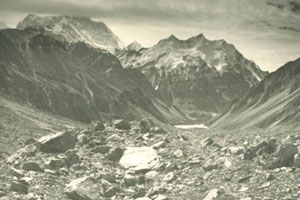
From Gamothang they proceeded to a place identified as Chumbab La (Photograph#98) (probably via Dzongri 3939m) where the trekking notes refer to magnificent gneissic rock formations strewn haphazardly along the slopes. During this part of the trek they enjoyed magnificent views of Kokthang Peak 6147m (Photograph#93), Ratong 5679m (Photograph#93), Little Kabru (Photograph#93), Kabru (Photograph#93), Kangchenjunga 8586m (Photograph#93), Simvu 6815m (Photograph#94), Pandim 6708m (Photographs#94,95), Jubonu (Photograph#95) and Narsing (Photographs#95,96). To the north-east they could see the Dongkya range (Photograph#96) and the Tibet – Sikkim border (Photograph#96).
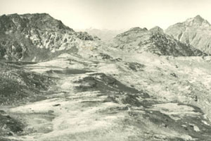
From the Kang La pass they made their way to Ghunsa via the Mirgin La pass (Photographs#102,103,104) From here they could see the Everest group to the west, Khabur 6332m (Photograph#104) and Phole Peak 6645m (Photograph#104) to the north and Jannu 7710m (Photograph#104) to the north-east. They had to negotiate the passes at Sinion La 4440m, the Sele La pass 4290m and the Tamo La 3940m prior to reaching Ghunsa (Photographs#105,106,107,108,109).
Ghunsa is a small village where there were a few farming Bhutia families that were involved in tending their yaks, sheep and goats and did some small scale potato farming. There was a small chowkidar's (headman) house and the expedition camped in the near vicinity. They also used the opportunity to restock some of their supplies and rest for a few days.
View of Everest from Ghara La pass
From Ghunsa they moved on to Khambachen (Photographs#110,111,112,113) which is about 12 km away. Along this route they could see the full majesty of the Kangchenjunga massif and also the amazing view of the tremendous north-west face of Jannu soaring upwards. Initially they trekked on the east side of the Ghunsa Khola, and about halfway, crossed over to the west side. Soon they were walking through rhododendrons, juniper and larch trees. This reach from Ghunsa to Kambachen has a few steep climbs: they neared Kambachen, they could see the whole Jannu massif and part of its glacial valley. Kambachen is located at 4175m.
From Kambachen the expedition moved to a open pasture area called Ramtang Kharka prior to entering the Ramtang Glacier (Photographs#115,116) on the right. They spent some time in the Ramtang glacier area and saw Ramtang Peak 6700m, Wedge Peak 6750m (now known as Chang Himal) (Photograph#117) and Kambachen Peak 7903m.
After they left the Ramtang Glacier, they made their way to Lhonak (Photographs#117,118), which is about 10kms from Kambachen. After negotiating a moraine, they arrived at the Yak pasture known as Lhonak 4815m. At Lhonak, they could see one end of the Kangchenjunga glacier (Photograph#119), Pang Pema 5100m (Photographs#118), Tent Peak 7365m (Photographs#119,121) (also known as Kirat Chuli) and Nepal Peak 6910m (Photograph#119).
From Lhonak, they turned north into the Lhonak glacier, made a small detour into the Tsisinla (?) glacier, and trekked to the base of Janak Chuli 7090m (previously called Outlier Peak) (Photographs#123,124,125) where they established a campsite near a small lake (Photograph#126) near Janak Chuli. From there they had magnificent views towards Drohmo Peak 6850m (Photograph#127) and the Kangchenjunga massif to the south-east. After this detour, they returned to the Lhonak Glacier (Photographs#127,128,130) and continued north to the Tibetan border where they had a view of Nupchu 6044m (Photographs#129,131,132) to the south-west and Lashar Peak 6930m (Photographs#128,130) to the north.
They returned down the Lhonak Glacier to Kambachen and made their way to the Jannu Glacier (Photographs#134,135,138,139,141,143,145,146) where they had extraordinary, spectacular close-up views of Mt. Sharpu 7070m (Photograph#144) and Jannu 7710m. (Photographs#134,135,136,137,138,139,140,141,142). After some time spent on the Jannu glacier, they returned to Ghunsa, and then to Darjeeling via the Yamatari glacier, Phalut and Sandakphu.
